Parts of northern Ontario are bracing for significant snowfall and potential freezing rain as Environment Canada issued multiple snowfall warnings Sunday morning.
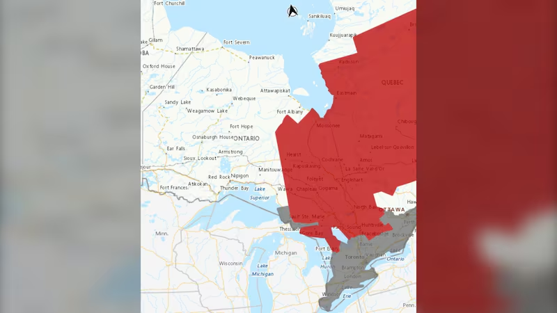
The affected regions include Timmins, Chapleau, Missinaibi Lake, Fraserdale, Pledger Lake, Gogama, Foleyet, Kapuskasing, Hearst, Smooth Rock Falls, Little Abitibi, Kesagami Lake and Moosonee. Snowfall accumulations of up to 15 centimetres are expected, with peak rates of 2 to 5 centimetres per hour.
In areas from Chapleau to Timmins and southeast, rain is forecast to transition to snow late Sunday morning, with a risk of freezing rain or ice pellets during the changeover. Locations northwest of these areas will see precipitation begin as snow.
Residents in the affected areas are advised to exercise caution and plan for potential travel disruptions throughout the day.
Northwesterly winds gusting between 50 and 60 km/h may cause local blowing snow, reducing visibility and creating hazardous travel conditions. Rapidly accumulating snow is expected to make highways, roads, walkways, and parking lots difficult to navigate.
Meanwhile, winter weather travel advisories have been issued for Sault Ste. Marie, St. Joseph Island, Searchmont, Montreal River Harbour and Batchawana Bay. Snowfall accumulations of 5 to 10 cm, with higher amounts possible north of Ranger Lake, are expected, along with a risk of freezing rain. A brief period of ice pellets or freezing rain may occur during the transition from rain to snow, particularly east of Sault Ste. Marie along the North Channel.
Environment Canada has advised motorists to prepare for hazardous winter driving conditions, reduce speed and maintain a safe following distance if visibility is reduced. Updates on road conditions are available through the Ontario Ministry of Transportation’s 511 Traveller Information Service.
The snowfall is expected to taper off by Sunday evening.
“Take frequent breaks and avoid strain when clearing snow,” said Environment Canada.

“Please continue to monitor alerts and forecasts issued by Environment Canada,” continues the weather alerts.
To report severe weather, send an email to ONstorm@ec.gc.ca or tweet reports using #ONStorm.


