A passing cold front will make for a colder March night on Wednesday into Thursday, but fair weather expected this weekend will see milder conditions due to a steady southerly wind.
Cold March night ahead
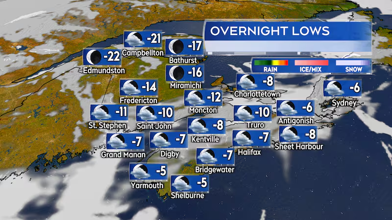
A northwest wind following the passage of a cold front is drawing colder air out of northern Quebec down into the Maritimes.
Temperatures were already below freezing Wednesday morning in New Brunswick. They fell to below freezing before noon in Prince Edward Island and are falling towards and below freezing in Nova Scotia Wednesday afternoon into evening.
The northwest wind is expected to persist through Wednesday night. Overnight low temperatures will be a few to several degrees below early March averages. It will mostly be -5 C to -10 C for Nova Scotia and Prince Edward Island. There will be lows of -10 C to -16 C in New Brunswick except -16 C to near -20 C for northern areas of the province.
It will be a cool to chilly Thursday afternoon for the Maritimes. Day time high temperatures will range from a few degrees below to a few degrees above the freezing mark. A mix of sun and cloud is expected across the region.
Weekend warm up
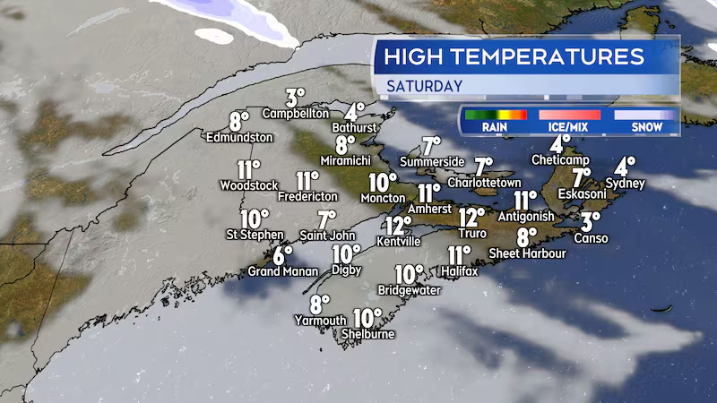
Between a slow-moving weather front to our west and high pressure in the east, the Maritimes will be put into an extended period of southerly winds this weekend.
The south wind will draw mild air up the U.S. eastern seaboard and into the Maritimes. There will be high temperatures on Saturday of 6 C to 12 C for much of the Maritimes. It will be as warm as 12 C to 15 C in the interior of southwestern Nova Scotia. Cooler conditions are possible in parts of northern New Brunswick and northern areas of Cape Breton with highs of 2 C to 6 C.
High temperatures on Sunday are projected to reach 10 C to 16 C for much of the region. Exceptions where the southerly wind is onshore directly off ocean waters. Areas such as the Bay of Fundy coastline and Atlantic coastal areas of Nova Scotia could have high temperatures of 4 C to 8 C due to the cooler marine wind. Sunday will be the cloudier day of the weekend with a chance of some patchy drizzle and showers.
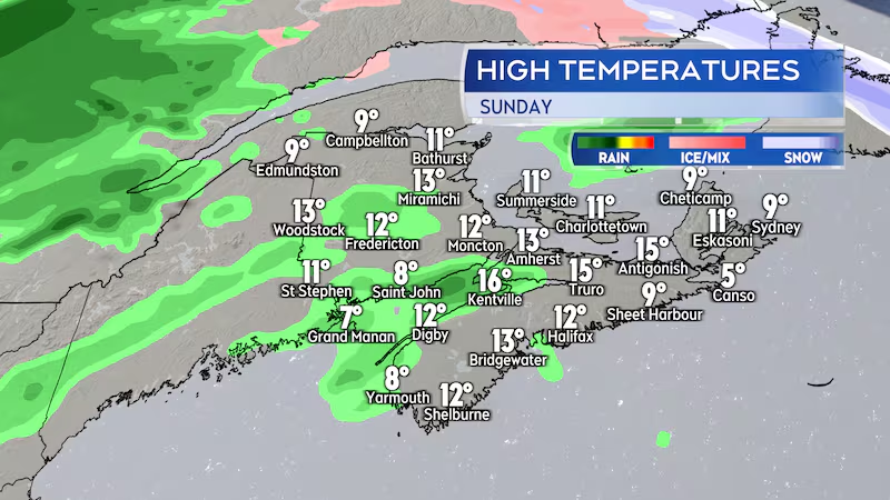
As the mild air from the south sits over the water and cools, it is likely do develop into fog banks and areas of patchy drizzle. Those types of weather conditions are most likely around the Bay of Fundy coastline of New Brunswick and the Atlantic coastline of Nova Scotia this weekend.
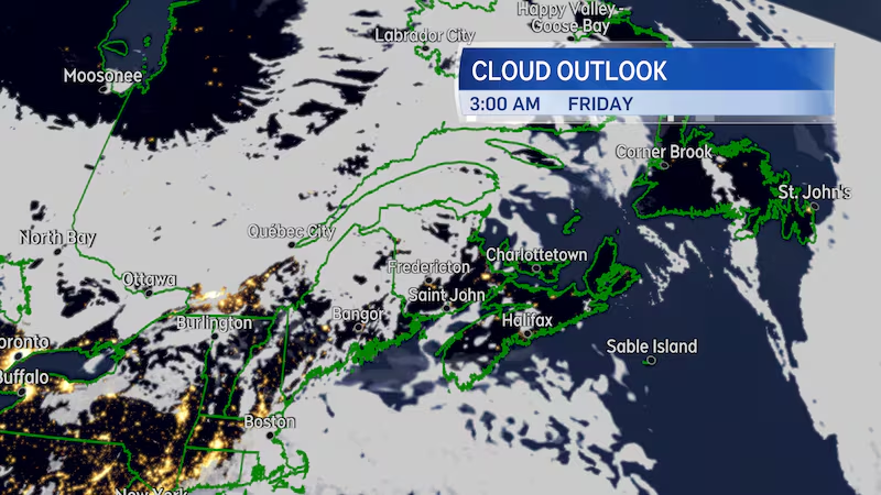
Lunar eclipse update
A lunar eclipse will be occurring very early Friday morning. The moon will start to enter Earth’s umbra (darkest part of the shadow cast by the planet) shortly after 2 a.m. ADT Friday and will be fully eclipsed by about 3:25 a.m. ADT. The full eclipse will last until about 4:30 a.m. ADT.
This will not be a complete blackout of the moon but will rather give the moon a dimmer brown-reddish hue.
Weather conditions in the Maritimes generally looking favourable for viewing the eclipse. Just a few clouds are present for Nova Scotia, Prince Edward Island, and southern New Brunswick. There will be partly cloudy conditions in northern New Brunswick.